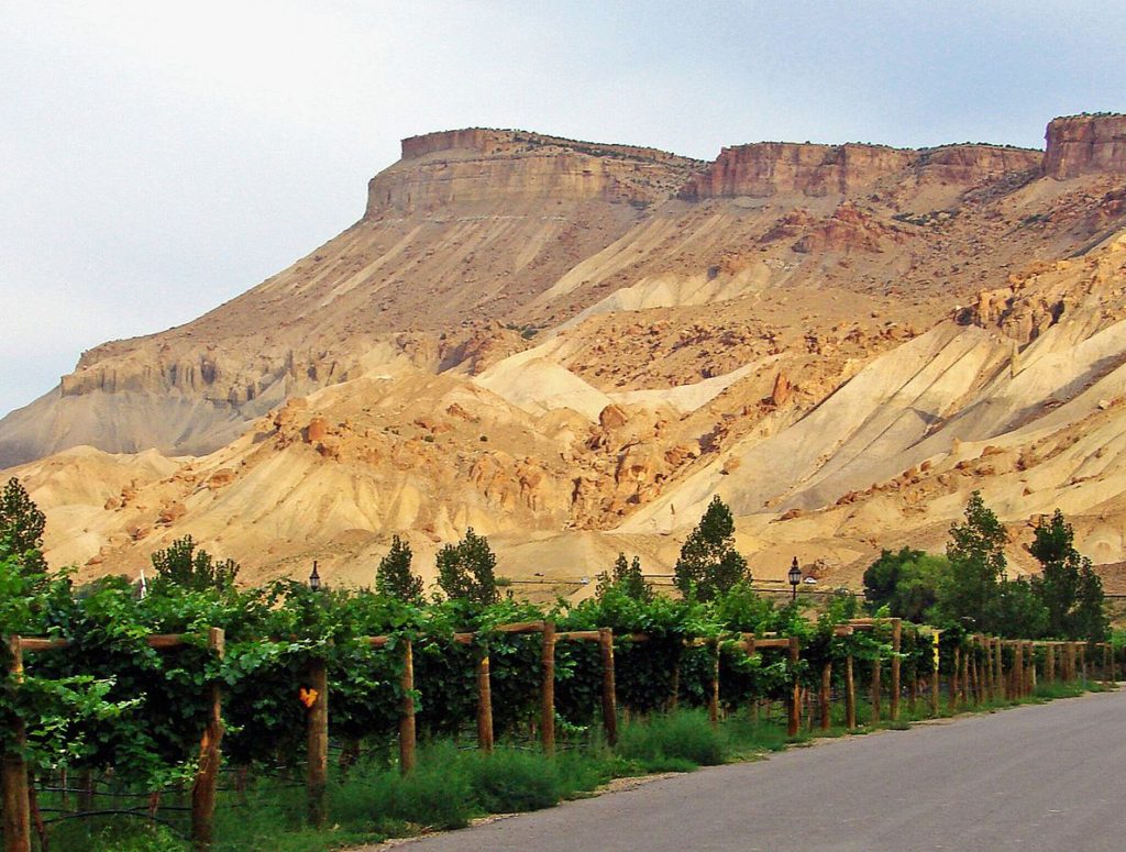
Mt. Garfield from Palisade, Colorado
Suddenly, the pine, fir and aspen trees are replaced by scrubby trees, red dirt and brown dusty hillsides. The landscape looks dry, high desert dry, with prickly looking shrubs dotting the landscape every so often. We’ve been driving I-70 going west through Colorado, and have crossed through the alpine environment to the Western Slope.
Spend enough time in Colorado, reading or listening to the local news, and you’ll become familiar with the phrase, the Front Range. The Front Range refers to the very first range of mountains you will encounter driving from the east across the plains. The Front Range is also frequently used to summarize the highly populated cities and towns that sit at the base of this first range of mountains.
Strangely, though there is a Front Range, there is no corresponding Back Range, but instead the Western Slope. The Western Slope also encompasses a large geographic area, although with a lot fewer people, referring to all the area west of the Continental Divide past the 13,000 and 14,000-foot peaks, past the snowy cirques to a land that seems starkly in contrast to our Rocky Mountains.
Not being familiar with Colorado, and only having a frame of reference from photos and movies showing those snowy peaks, I was a bit taken aback coming to the Western Slope. Suddenly the mountains were gone, instead replaced by what seemed to be a desert, a wasteland, with very few specks of green. How could this be Colorado?
I got to experience the Western Slope up close and personal for two years, when my husband I lived in Palisade, Colorado — just about ten miles to the east of Grand Junction. Strange sedimentary cliff-like structures that somehow reminded me of Egyptian pyramids rose above our home to the north. I soon found out those cliffs were comprised of various layers of sedimentary rock, chief among them, something called Mancos Shale.
I also found out that Mancos Shale has an interesting and some frustrating property to it when it gets wet. Hiking Mt. Garfield, the highest peak of the Bookcliffs, was a frequent favorite for us. While the hike up Mt. Garfield is only two miles, don’t let that fool you. It is a work out. It goes up over 2000 feet during that two miles, sometimes at very steep grades up sandy, loose ridges with no switchbacks.
One winter day, I had dropped off Bryon at the Grand Junction airport for a business trip, and decided to take our dog, Simon, for a hike up Mt. Garfield. It began to snow while were on the summit, and as we descended, the snow turned into rain. The Mancos Shale turned into something akin to wet cement, caking the bottoms of my hiking boots, turning them into giant blocks of caked on shale that was two inches thick on the bottom of my boots by the time we reached the car. I literally felt like I was walking with concrete blocks attached to my feet.
Simon had a similar effect to his paws, also getting coated in this thick stuff that started to dry like cement or concrete. The only thing I could do for him, was to soak his paws in pails of water, and work the shale out between his pads by massaging his paws one at a time.
Despite the lack of green, there is a beauty to the Western Slope. The contrast of the beiges, oranges and reds of the sediment and the desert wildflowers make for some stunning vistas, especially at sunset. I grew to appreciate this unique landscape during our time there. But the Western Slope also confirmed what I also knew deep down — I am a mountain person –and I craved the alpine forest, high peaks and always felt something was missing. So in a strange way, our time there led me to our home in Nederland, knowing that was where I truly belonged.