“What’s a good early summer summit hike I can do?”
When I worked as a Park Ranger at Rocky Mountain National Park, visitors frequently asked this question. Many of the popular peaks within the park can be snow packed until Fourth of July, which can be frustrating for those anxious to ascend a peak.
Early Season Summit Hike
But a favorite hike that melts out fast, offers a good challenging climb, as well as stellar views is the 8-mile round trip hike up Twin Sisters. And so, when Bryon asked me what I wanted to do for my birthday this week, a hike up Twin Sisters seemed the perfect activity.
Only a 45-minute drive from Nederland, Twin Sisters is accessible off Highway 7 right across from Lily Lake parking lot. The two double peaks top out at 11,400 and offer 360 degree views from the plains to Lake Estes to Longs Peek and Mt. Meeker.
A hike up Twin Sisters also offers an up close and personal look of the damage from the 2013 floods as well.
Forest Shade
To begin the hike, turn right up the road across from Lily Lake. Do not park in the lot by the road as this is overflow parking for Lily Lake. If you drive up the road about one half mile, you will find parallel parking on the right hand side of the road.
To start the hike, walk past the wooden barricade up the old dirt road to the trail head sign on the left. It’s quite nice to hike Twin Sisters on a hot day, as the first 2 1/2 miles is wooded with plenty of shade. As you walk those first couple of miles, you’ll witness first hand the effects of fire suppression. Crowded stands of skinny Ponderosa Pine pack the forest, creating an unnatural ecosystem. The density of Ponderosa has deprived other species from growing as well as grasses and wildflowers.
After about a mile, you’ll start a very long traverse due south. During this traverse, a break in the forest provides a nice spot for a break and a stunning view of Mt. Meeker and Longs Peak.
Flood Damage
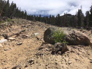
Landslide from 2013 flood
Before the flood in September, 2013, the trail continued to switchback through the forest for the next two miles. Now, you encounter a break in the forest where a huge landslide wiped out a large swath of trees during this 1000-year rain event. Walk through the slide, witnessing the power of water and the devastation it left behind. The terrain is uneven where humps of mud were left behind and dead trees still poke up at odd angles where they were left behind. In fact, 13 separate landslides impacted the park during the flood, and many parts of the park were forever changed.
Because of the landslide, the trail becomes quite steep after crossing through the slide. After the flood, visitors created use trails when the original trail was wiped out. Most trails within the park are created with gentler grades to accommodate stock use, but the visitor use trail took a steeper more direct path that is now the main trail.
A Grand View
After less than a mile of huffing and puffing, the newer section of trail hooks back in with the old trail and becomes gentler. As you continue to climb closer to timberline, you’ll notice a change in the pine along the trail. The needles on the branches are bushy and thick, resembling bottle brushes. You’ve encountered the Limber Pine, named for its branches that flex and bend in the wind at the high elevations.
Soon after you go by the hitching post, you will break out of the forest entirely into the talus rock. Looking up to your right, the double summits loom above. Views are plentiful. On a clear day, you can see all the way to the plains. Turning to your north, Lake Estes appears.
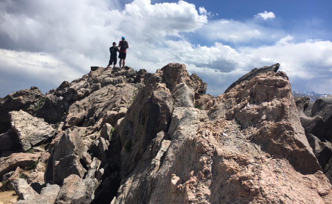
A few more switchbacks lead you to the saddle between the double peaks. Going right by the stone hut is the more popular destination and brings you to the summit of the western peak within five minutes. A lengthier scramble to the left will lead you to the eastern summit.
Your climb of 2,400 feet has led you to one of the more stunning views in the park. Enjoy!